

5-Day Itinerary for Iceland’s South Coast
No part of Iceland shows the clash of fire and ice as vividly as the South Coast. Here, the Mid-Atlantic Ridge cuts straight across the land, leaving a trail of volcanoes – Hekla, Katla, and Eyjafjallajökull among them – that have shaped the region for centuries. Glaciers pour down from Vatnajökull in ragged tongues. Some end in lagoons where icebergs break free and drift toward the sea. Black-sand plains stretch to the horizon, while waterfalls pour from mossy cliffs wherever a river finds its way to the sea.
The human story is just as deep. Þingvellir, where Iceland’s parliament was founded in 930, sits at the gateway to the south, while fishing villages and farmsteads along the coast still echo with centuries of survival in a harsh but bountiful landscape. Today, this is the country’s most-visited region, home to the Golden Circle, geothermal pools, glacier lagoons, and some of the most iconic scenery in all of Iceland.
This 5-day itinerary follows that coastline east from Reykjavík, balancing famous sights with quieter stops. It’s a compact journey – about 1,225 kilometers (761 miles) in total – but one that captures the drama, history, and beauty that make South Iceland unforgettable.
Day 1: Campervan Pickup & The Golden Circle
You land on a peninsula of fresh lava and steam. Reykjanes is your first glimpse of the forces that shape the south: a live rift, hot rock close to the surface, and Atlantic weather rolling in fast. Pick up your campervan, stock up on groceries, and point the nose inland – the classic Golden Circle threads together the story of how Iceland came to be and how people learned to live here.
Þingvellir National Park – Where a nation was founded
It’s at Þingvellir where the North American and Eurasian plates pull apart a few centimeters each year, cracking the ground into dark fissures and the long cleft of Almannagjá. On this same plain, Icelanders founded the Alþingi in 930, meeting each summer to settle laws and disputes. It’s a fantastic first stop to make, offering wonderful landscapes and also a taste of what’s to come. From the Hakið viewpoint, you can look down over the rift valley, then follow the path through Almannagjá Gorge itself. A short trail leads to Öxarárfoss, a picturesque waterfall framed by lava walls.

Geysir Geothermal Area – Strokkur and the valley of steam
The geothermal field at Haukadalur, also known as Geysir, stretches for about 3 sq km (1 sq mile), dotted with more than 70 bubbling hot springs, mud pots, and fumaroles. Steam drifts across the valley, carrying a faint scent of sulfur, while mineral deposits stain the ground in shades of yellow, orange, and red.
The Great Geysir, which gave its name to all the world’s geysers, lies dormant now – its broad pool ripples but hasn’t erupted in a long time. Nearby Strokkur is the real draw. Every 5–10 minutes its blue pool swells, sighs, and bursts skyward, sending scalding water up to 30–35 m (100–115 ft).

Gullfoss Waterfall – Iceland’s golden cascade
The Hvítá River charges south from the glacier fields of Langjökull before plunging in two stages into a sheer-walled canyon – the waterfall called Gullfoss. The upper tier drops 11 m (36 ft), then the river makes a sharp turn and crashes another 21 m (69 ft) into the gorge below. From the canyon rim, the water seems to vanish into the earth; from the lower path, you’re close enough to feel the spray on your face. Rainbows often arc across the mist on sunny days, the “golden” light that gives the falls their name.
In winter, Gullfoss is edged with ice, the frozen cliffs and drifting spray making the gorge even more dramatic. In summer, the surrounding meadows glow green, a striking contrast to the bare highlands visible on the horizon.

Secret Lagoon – Iceland’s Oldest Pool
Tucked away in the village of Flúðir, the Secret Lagoon (Gamla Laugin) is Iceland’s oldest swimming pool, first built in 1891. Surrounded by steaming vents and bubbling hot springs, the pool has been restored but still feels rustic, with simple changing huts and a natural, rock-edged basin. At one end, a tiny geyser erupts every few minutes, sending up a plume of steam as bathers float in the warm water.
Before Icelanders had modern swimming pools, locals in Flúðir gathered here to bathe, socialize, and even learn to swim. Today, it remains one of the most atmospheric places to experience the country’s bathing culture – less flashy than the Blue Lagoon, but far more authentic.
The water sits at a comfortable 38–40°C (100–104°F) year-round, making it a perfect stop after the Golden Circle loop. In winter, snow piles along the pool’s edge while the water steams; in summer, long daylight hours make for lingering evening soaks.

Overnight in the Golden Circle
Stay overnight in the Golden Circle region so you’re ready to roll straight into the South Coast tomorrow. If you’re camping, Reykholt Campsite is a reliable choice with hot showers, a shared kitchen, and powered pitches. Guesthouses and farm stays nearby offer cozy alternatives, often with geothermal hot tubs and countryside views.
For more services, you can also push on to Selfoss, the main hub of South Iceland, about 45 minutes down the road. The town has supermarkets, restaurants, and a well-equipped campsite, making it a practical base if you prefer extra amenities before heading east.

Day 2: South Coast Wonders on the Way to Vik
Leaving your campsite, continue east on the Ring Road into some of Iceland’s most photographed landscapes. Today brings a string of waterfalls, black-sand beaches, and volcanic features on the way to the coastal village of Vík.
Kerið Crater – A lake in a volcano
Begin the morning with a short detour to Kerið, a 3,000-year-old explosion crater. Its steep red slopes drop into an aquamarine lake, often fringed with moss or snow depending on the season. A trail circles the rim in 15 minutes, with side paths leading down to the water’s edge. In clear weather, the contrast of blue, green, and rust-colored rock is striking. Allow 30–40 minutes here before continuing east on the Ring Road.

Seljalandsfoss & Gljúfrabúi – Walk behind the falls
An hour farther along lies Seljalandsfoss, where a ribbon of water plunges 60 m (197 ft) over a cliff into a spray-filled bowl. A path loops behind the curtain, offering a rare chance to stand inside the waterfall itself – just bring a rain jacket. A short walk north along the cliff reveals Gljúfrabúi, a smaller fall hidden inside a mossy gorge and all the more magical for it.

Skógafoss & Kvernufoss – Icons and a hidden gem
Another 30 km down the Ring Road, the roar of Skógafoss fills the valley. At 62 m (203 ft) high and 25 m (82 ft) wide, it’s one of Iceland’s most powerful waterfalls. On sunny days, double rainbows form in the spray at its base. A staircase climbs 527 steps to a viewpoint above, where the Fimmvörðuháls trail begins, winding between glaciers. Just beyond the Skógar Museum, a short hike through a green gorge leads to Kvernufoss, a quieter 30 m (98 ft) cascade you can also walk behind in summer.

Dyrhólaey – Arch and puffin cliffs
West of Vík, the headland of Dyrhólaey juts into the Atlantic, crowned by a natural arch where waves crash through the cliffs. In summer, puffins nest on the grassy slopes, while year-round, the views sweep over Reynisfjara’s black sands to the sea stacks beyond. The upper viewpoint requires a short, steep drive or walk, but the payoff is spectacular: panoramic vistas over the Mýrdalssandur plains and glaciers inland.

Reynisfjara Black Sand Beach – Basalt cliffs and sea stacks
Before reaching Vík, stop at Reynisfjara, the country’s most famous black-sand beach. Here, perfect hexagonal basalt columns rise like an organ pipe wall from the cliffs, while offshore the Reynisdrangar sea stacks jut from the surf. Folklore says they were trolls frozen by the sun as they tried to drag a ship ashore. The scenery is spectacular, but the Atlantic is treacherous: sneaker waves can surge higher than expected, so keep well back from the waterline and always face the ocean.

Overnight in Vík
End the day in the small coastal village of Vík, ringed by cliffs and sea views. Its campground and guesthouses make a good base, and you’ll be well placed for glacier lagoons and lava fields further east tomorrow.

Day 3: Glaciers, Lagoons, and Ice Caves
East of Vík, the road slips into Vatnajökull’s shadow, where glaciers edge down to the Ring Road and lava plains stretch toward the sea.
Eldhraun Lava Fields – Moss over fire
Not far east of Vík, you’ll cross the Eldhraun lava field, a green, undulating expanse that covers 565 sq km (220 sq miles). Its quilt of woolly fringe moss hides the scars of one of Iceland’s greatest natural disasters: the Laki eruption of 1783–84, when months of lava flows and toxic gases devastated the country and changed climate patterns across Europe. Today, it’s eerily quiet. Walking on it is forbidden, since each patch takes a century to recover.

Skaftafell – Trails and glaciers
Once a national park in its own right, Skaftafell has been part of Vatnajökull National Park since 2008. It’s a hiker’s playground, with around 60 km (37 miles) of marked trails ranging from easy walks to demanding ridge climbs. The most popular is the trail to Svartifoss, a waterfall framed by hexagonal basalt columns, while short paths lead to viewpoints like Sjónarnípa, looking out over the blue ridges of Skaftafellsjökull glacier. For something more immersive, join a guided glacier hike on Vatnajökull’s outlet tongues. Tours outfit you with crampons, helmets, and ice axes, leading you safely over crevasses and into shimmering blue ice. Allow at least half a day here if you want to explore properly.

Jökulsárlón Glacier Lagoon – Icebergs on the move
East of Skaftafell, the road suddenly opens onto Jökulsárlón, Iceland’s most famous glacier lagoon. Formed in the 1930s as Breiðamerkurjökull retreated, the lake is now around 27 sq km (10 sq miles) and over 280 m (920 ft) deep. Huge icebergs continually calve from the glacier and drift through the lagoon, their surfaces glowing in shades of sapphire blue, some streaked with volcanic ash. Seals often swim among them, popping up between the floes. Boat tours skim across the lagoon, with zodiacs able to nose closer to the glacier face, while in winter (Oct–Mar) the focus shifts to guided ice cave tours beneath Vatnajökull’s shimmering blue vaults.

Diamond Beach – Crystals on black sand
A short walk from the lagoon, icebergs that have floated down the river outflow wash up on the volcanic sands of Breiðamerkursandur, better known as Diamond Beach. The contrast is mesmerizing: crystal-clear ice scattered across jet-black sand, like gemstones on velvet. The scene shifts constantly as waves polish and reshape the ice, leaving new sculptures each day.

Overnight in Skaftafell or Höfn
Options include campgrounds near Skaftafell or in Höfn if you prefer to push farther east. Either way, tonight you’ll fall asleep close to the edge of Europe’s largest ice cap.

Day 4: Return Through the South
On the return west, the South Coast still has plenty of secrets to uncover. Today’s route winds back along the Ring Road past mossy canyons, black-sand headlands, and one of Iceland’s most atmospheric pools, before ending in geothermal Hveragerði.
Fjaðrárgljúfur Canyon – A mossy ribbon of water
Formed at the end of the last Ice Age around 9,000 years ago, Fjaðrárgljúfur is a 2 km (1.2 mile) gorge carved by the Fjaðrá River. Its walls rise up to 100 m (330 ft), cloaked in soft moss that gives the whole canyon a storybook feel. The winding river has drawn filmmakers and pop stars alike – scenes of Game of Thrones were shot here, and Justin Bieber’s music video made the site an internet sensation. A marked trail follows the canyon rim to several viewing platforms, including one overlooking Mögáfoss. Stick to the path to protect the fragile moss.

Seljavallalaug – A pool beneath the volcano
Hidden in a narrow valley below Eyjafjallajökull, Seljavallalaug is one of Iceland’s oldest man-made pools, built in 1923. A 15–20-minute walk from the parking area leads you along a rocky riverbed to the mossy concrete basin, where a hot spring still trickles in. Temperatures vary between 20–35°C (68–95°F), warmer near the inlet and cooler at the far end. The facilities are minimal – changing rooms but no showers – but the setting is unforgettable. Ash from the 2010 eruption once buried the pool, only for volunteers to dig it out again the following year.

Optional Add-Ons – Hidden stops and detours
If you’ve got extra time on your return west, the South Coast offers a handful of worthwhile detours:
- Icelandic Lava Show (Vík) – The world’s only live lava show, where real molten lava (1100°C / 2000°F) is poured out in front of you. Educational, theatrical, and surprisingly beautiful.
- Sólheimasandur Plane Wreck – A US Navy DC-3 that crash-landed here in 1973 has become one of Iceland’s most photographed sights. The wreck sits 4 km (2.5 miles) across the black sand from the Ring Road; allow 45–60 minutes each way on foot, or you can pay for the shuttle to whisk you there in 5 minutes.
- Sólheimajökull Glacier – An outlet tongue of Mýrdalsjökull, this glacier is easy to reach via a short drive from the Ring Road. Trails lead right up to the snout, where you can see crevasses and blue ice close up, or join a guided hike onto the glacier itself. It’s one of the most accessible places in Iceland to experience glacial landscapes.
- Íráfoss Waterfall – Just off the Ring Road between Skógafoss and Seljalandsfoss, this graceful 30 m (98 ft) cascade tumbles over basalt cliffs but sees far fewer visitors than both of the aforementioned waterfalls. A quiet stop if you want a cascade all to yourself.
- Nauthúsagil Canyon – A narrow gorge near Seljalandsfoss, shaded by rowan trees and mossy walls. A short, adventurous scramble over rocks and shallow streams leads to a hidden waterfall at the canyon’s end.
- Lava Centre (Hvolsvöllur) – A high-tech exhibition exploring Iceland’s volcanic systems, eruptions, and earthquakes, with interactive displays and a panoramic viewing platform. Great context if you want to better understand the landscapes you’ve been driving through.

Overnight in Hveragerði – The geothermal town
End the day in Hveragerði, where steam rises from the hillsides and hot water bubbles beneath gardens and greenhouses. Known as Iceland’s “Geothermal Town,” it has one of the best public pools in the country, complete with hot tubs and a steam room fed straight from the earth. For dinner, try Danish-inspired Matkráin or the lively Greenhouse Food Hall with its mix of restaurants. Campsites and hotels alike make this a comfortable final stop before returning to Reykjavík or Keflavík.
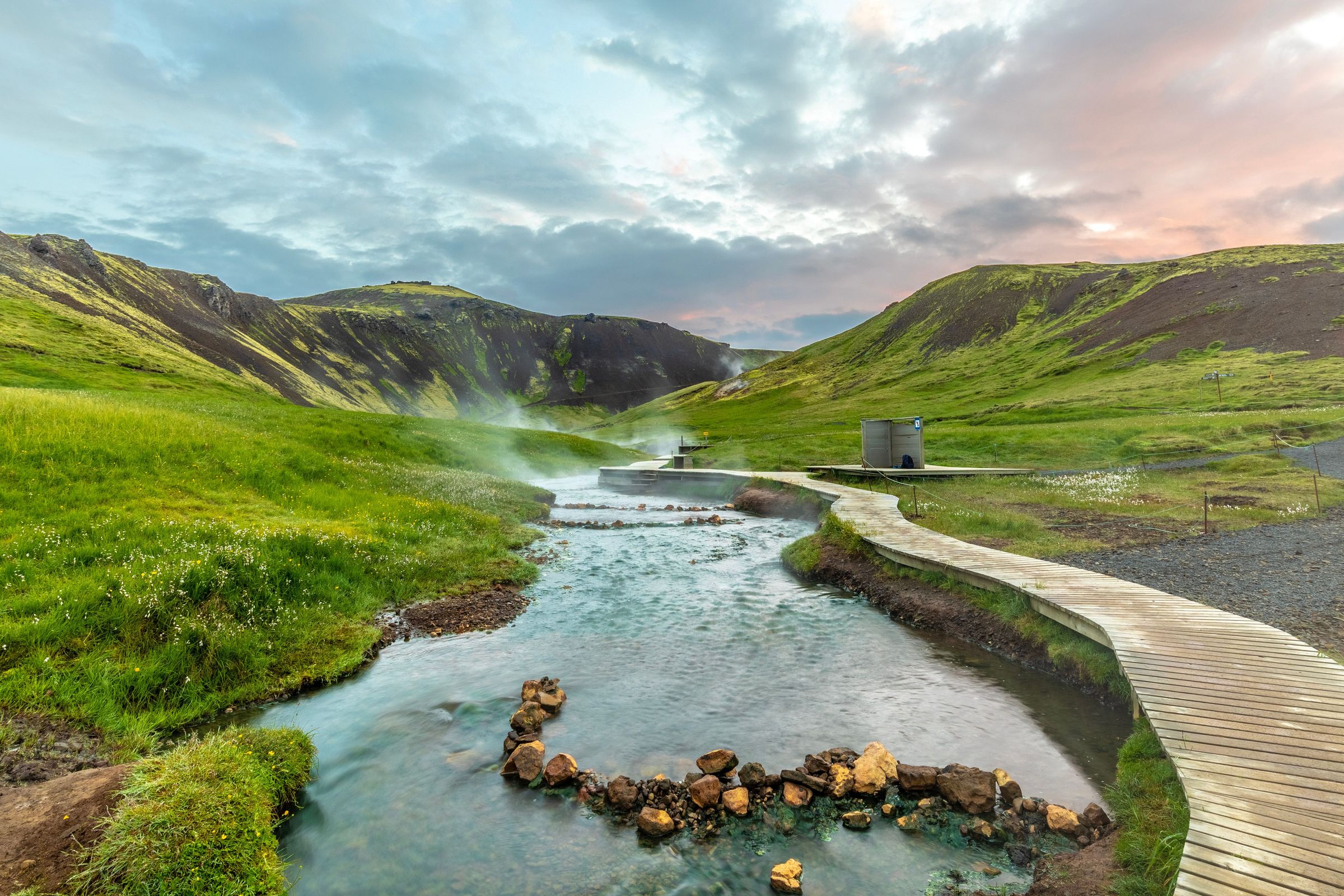
If you’ve driven straight here without any detours, you might find yourself with plenty of time to do the hike to the Reykjadalur Hot Spring River, one of the coolest natural springs in the country.
Day 5: Craters, Coastlines, and the Capital
Your last day in Iceland can go one of two ways. If you fancy a bit of time in the capital, this is a good day to drive straight from Hveragerði into Reykjavík and spend the day exploring its museums, shops, and lively food scene before your flight home.
If you’d rather stay immersed in nature, continue across the Reykjanes Peninsula, where steaming vents, lava cliffs, and the Atlantic’s edge offer a final taste of Iceland’s wild side.

Brimketill – Lava pool on the edge of the Atlantic
A short drive west, the ocean crashes into the black cliffs at Brimketill, a natural rock pool carved by wave erosion. From the viewing deck, you can watch spray explode against the lava ledges – dramatic in any season, but especially fierce when winter storms roll in.

Gunnuhver – Iceland’s largest mud pool
At Gunnuhver, boiling clay churns in a cauldron nearly 20 m across, sending clouds of steam drifting over the surrounding lava. Boardwalks take you safely across the geothermal field, where fumaroles hiss and the ground is streaked with bright mineral colors. The site is named after a ghost, “Gunna,” said to have been trapped here centuries ago.

Reykjanesviti Lighthouse – Sentinel of the southwest
Perched on a grassy headland above crashing surf, Reykjanesviti is Iceland’s oldest lighthouse, first lit in 1878. The current structure dates to 1907 and still watches over ships rounding the peninsula. The surrounding cliffs offer superb coastal views, with seabirds wheeling above in summer.

Blue Lagoon – Soak before you fly
End your trip with a geothermal bath at the Blue Lagoon, just 20 minutes from Keflavík Airport. The milky-blue waters hover around 38°C (100°F), rich in silica and minerals that soften the skin and create surreal white deposits on the surrounding lava. Book ahead – spaces fill fast – and allow a couple of hours to float, relax, and reflect on your journey.

Farewell to Iceland
From the Blue Lagoon, it’s only 20 minutes to the GO Campers office, making it an easy final stop before dropping off your vehicle. If you’re flying out today, you can head straight to the terminal refreshed. If your flight is tomorrow and you have one more night to camp, Reykjavík’s campsite is less than an hour’s drive away – a good chance to enjoy one last evening in the capital, with its restaurants, bars, and geothermal pools, before saying goodbye to Iceland.

A Whirlwind 5 Days in Iceland
Five days on Iceland’s South Coast is a crash course in the island’s defining contrasts. Along this stretch of Ring Road, you’ve walked between tectonic plates at Þingvellir, stood in the spray of thundering waterfalls, watched geysers erupt, and traced the black-sand shoreline east to glaciers and iceberg lagoons. It’s a route shaped by fire and ice, but also by centuries of human resilience – farmsteads at the foot of volcanoes, old pools tucked into valleys, and fishing villages facing the Atlantic.
Five days is just enough to sample the south’s highlights, but also to hint at more – hidden valleys, highland trails, or the tranquil corners you spied on your drive. However, you’ve chosen to spend it, this journey captures the essence of Iceland: raw, dramatic, and unforgettable.
Frequently Asked Questions About Iceland's South Coast


