The Diamond Circle stretches 250-260 kilometers (155-160 miles) through northeastern Iceland. This spectacular route is designed to round up several amazing natural attractions in one easy driving tour; you can drive it in about 4 hours without stops, but like most things in Iceland, the more time you have here the better – there are some seriously impressive natural sights to check out in this region.
In this article, we’re going to go over everything you need to know about Iceland’s Diamond Circle. We’ll cover what exactly it is, the attractions you can see, how long you need to explore it properly, and put it all down on a map so you can load it onto your phone and hit the road.
What is the Diamond Circle in Iceland?
The Diamond Circle in Iceland is a striking 250–260-kilometer (155-160 mile) sightseeing route in the northeastern part of the country that showcases some of Iceland's most spectacular natural attractions and landscapes. This circuit became an official tourist route in September 2020, designed to draw more visitors to the remote north, and has become the northern equivalent to the famous Golden Circle near Reykjavik.
Overview of the Diamond Circle Route
The Diamond Circle links five standout destinations that capture the raw beauty of North Iceland:
Ásbyrgi Canyon - A striking crescent-shaped canyon with walls that reach up to 100 meters in height; it’s also a place linked to mythical origins.
Húsavík - Húsavík is Iceland's bustling whale watching capital, facing out towards the northern ocean.
The route creates a loop that usually starts and ends in either Akureyri or Húsavík. Most of the area lies within the Northern Volcanic Rift Zone, where the North American and Eurasian tectonic plates are slowly pulling apart; this creates extraordinary geological features like bubbling hot springs, volcanic lake beds, and dried lava formations.
The Diamond Circle's roads are fully paved and easy to navigate during summer. The route became more available year-round after Route 862 to Dettifoss was upgraded, replacing a rough gravel road with a modern paved road.
Rent a Campervan in Iceland
Visit the most stunning places of the island with complete freedom
Both the Golden Circle and the Diamond Circle cover around 250 kilometers, but they offer very different experiences, both in terms of landscape and logistics.
The Golden Circle, located in South Iceland just outside Reykjavík, includes three world-famous sights: Þingvellir National Park, Geysir Geothermal Area, and Gullfoss Waterfall. These stops are all easily accessible year-round and can be visited in a single day, making the Golden Circle the most popular day trip in Iceland.
The Diamond Circle, by contrast, is set in North Iceland, with Akureyri or Húsavík serving as natural starting points. Instead of iconic sites clustered together, the Diamond Circle covers a wider variety of landscapes. You’ll also see fewer tour buses and crowds here, which makes for a quieter, more immersive experience.
Access is another key difference. The Golden Circle can be reached from Reykjavík in under an hour, while the Diamond Circle is a solid 6–10 hour drive from the capital. It’s best tackled as part of a Ring Road trip or a multi-day North Iceland adventure.
Weather and road conditions can also differ: the Golden Circle is open year-round and very well maintained; the Diamond Circle, while now mostly paved, can still be affected by snow and ice in winter, especially in more remote sections like Dettifoss or Ásbyrgi, with roads that aren’t regularly serviced in winter, if at all.
In short, the Golden Circle is Iceland’s classic highlights reel, while the Diamond Circle offers a deeper dive into wild, volcanic landscapes that feel less touched by tourism. It’s also a bit more difficult to complete in one day. Both are unforgettable, but they serve different kinds of trips – and different kinds of travelers.
Why it's called the Diamond Circle
The name comes from the route's diamond-like pattern on the map (with a bit of imagination!) and its big-hitting attractions.
This tourist route's story began in 1994, when Húsavík locals thought of creating a northern alternative to the Golden Circle to boost North Iceland's tourism. "Demantshringurinn," the Icelandic name, means "Diamond Ring" or "Diamond Circle".
Top Attractions on the Diamond Circle Route
The Diamond Circle features five remarkable attractions that showcase North Iceland's natural wonders, and a handful of other stops between for those with more time on their hands.
Lake Mývatn and its volcanic surroundings
Starting off at the route’s southernmost point, Lake Mývatn is a geological wonder that emerged about 2,300 years ago from a massive basaltic lava eruption. This shallow lake spans 37 square kilometers (14 square miles) with an average depth of 2.5 meters. People named it "Lake of Midges" (Mývatn) because of the tiny insects that fill the area during summer.
The landscape around the lake features remarkable volcanic formations. Visitors can see pseudo craters, lava pillars, and rootless vents that formed when hot lava met wetlands. The lake's ecosystem supports amazing biodiversity, particularly its bird populations. Duck species flock here from northwestern Europe each spring, making it a dream destination for birdwatchers.
You could easily spend a whole day here – there are easy-going hikes at the Skútustaðagígar Craters, Dimmuborgir Lava Field, and up to the top of the Hverfjall Volcano. Then, the Mývatn Nature Baths make for a steamy dip to refresh yourself.
Dettifoss – Europe's most powerful waterfall
Dettifoss is the most powerful waterfall in Europe, and definitely the biggest highlight of the Diamond Circle route. The waterfall's power makes the surrounding landscapes vibrate; while it’s only 44-45 meters high, it’s the sheer amount of water that plunges down the waterfall every second that makes Dettifoss so impressive – about 193 cubic meters per second. It’s a part of the Vatnajökull National Park, the glacier feeding the river and glacial floods behind the canyon itself.
Visitors can reach Dettifoss from two sides. The west side has a paved Road 862 that suits all vehicles. The east side's Road 864 is a gravel route – it takes longer to reach the viewing area, and a 4x4 is better suited for this route.
Ásbyrgi Canyon
Ásbyrgi Canyon sits at the northern tip of the Vatnajökull National Park, reached via the same roads as Dettifoss. It’s like a huge imprint of a horseshoe in the earth – legends say that it came from Sleipnir's hoofprint – Odin's magical eight-legged horse – as it leaped across the sky. The canyon stretches 3.5 kilometers in length and 1.1 kilometers in width, with cliff walls that soar up to 100 meters.
Science tells us catastrophic glacial flooding from Jökulsá á Fjöllum river shaped the canyon. The initial carving happened 8-10 million years ago, with more shaping about 3,000 years ago. There are plenty of great hiking trails to enjoy around the rim of the canyon, and there’s a tranquil birch and willow forest at the base of the canyon, with a nice pond filled with ducks; a green haven in the otherwise bare landscapes that make up this part of the country.
Húsavík – Whale watching capital of Iceland
From Ásbyrgi, continue onwards to Húsavík, Iceland's whale watching capital, with the country's highest sighting success rate. The town started its first scheduled whale tours in the mid-1990s after tourists showed interest to the local fishermen in the harbor, and the rest is history.
Skjálfandi Bay's rich ecosystem makes Húsavík perfect for whale watching. Melting snow and rivers bring nutrients that mix with three ocean currents to create ideal feeding grounds for marine life. The waters attract up to 23 different species of cetaceans. Visitors might spot humpback whales, minke whales, harbor porpoises, and blue whales – the largest animals that ever lived. The town itself is quite pretty, and has a clutch of good restaurants and cafes that hug the harbor.
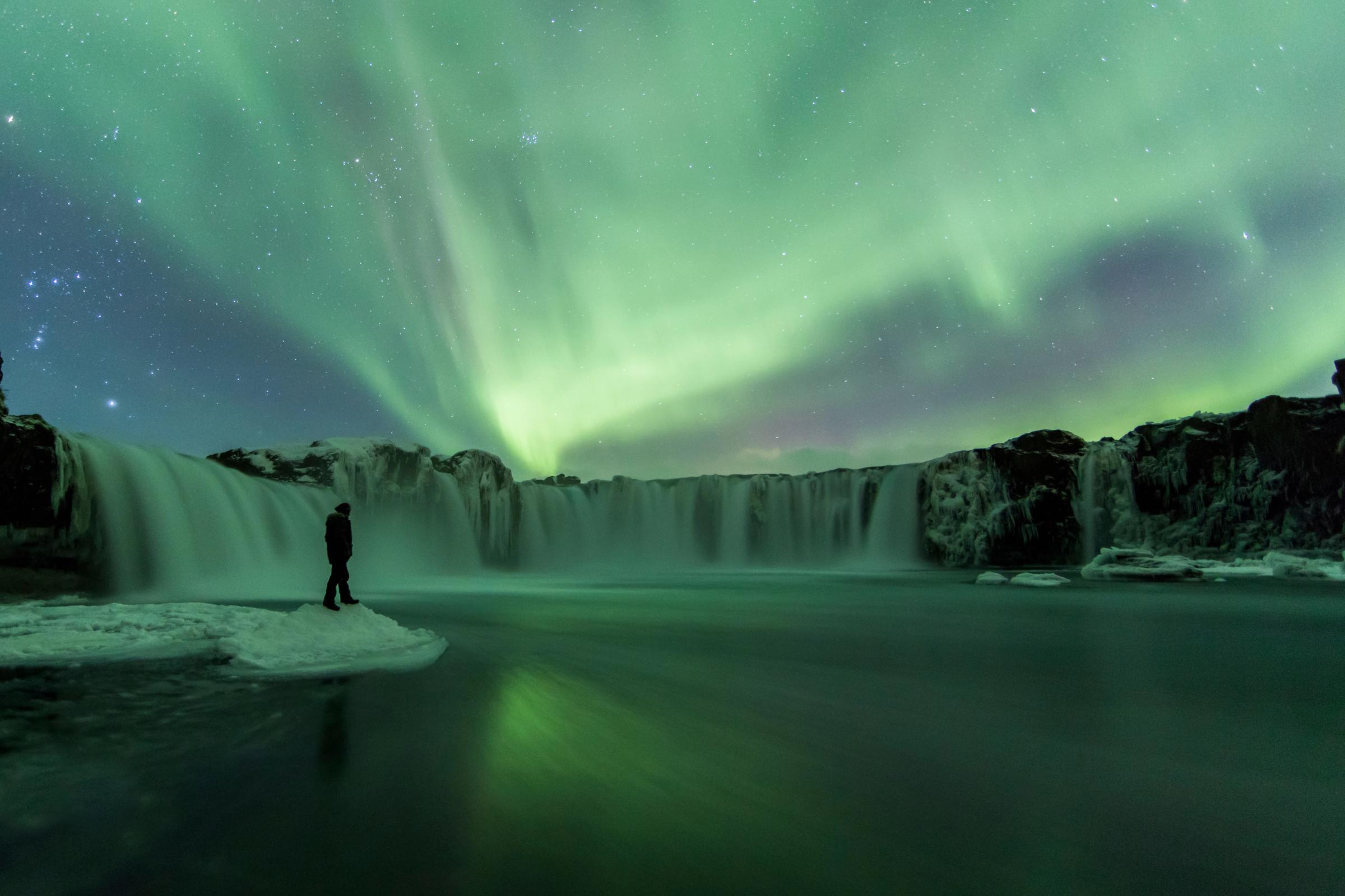
Goðafoss – The Waterfall of the Gods
The waterfall Goðafoss tells a powerful story of Iceland's history. The year 1000 AD marked a turning point when Þorgeir Þorkelsson, chieftain and law speaker, threw pagan idols into these falls on his return from that year’s Althing gathering at Thingvellir. This symbolic act represented Iceland's shift from Norse mythology to Christianity.
The waterfall creates a beautiful semicircular arc. The Skjálfandafljót river drops 12 meters across its 30-meter width. The waterfall's location between Akureyri and Lake Mývatn, on the Ring Road, makes it an easy stop on the Diamond Circle coming to or from the capital of the north.
Diamond Circle Detours Worth Exploring
We’ve covered the major highlights of the Diamond Circle. But like in so many other places in Iceland, there are plenty of amazing spots to see in between, which is why we recommend exploring this region over 2 days if you can spare the time.
Dimmuborgir lava fields
East of Lake Mývatn, Dimmuborgir is a wild maze of lava pillars, caves, and craggy towers that look like a ruined fortress. The name means “Dark Castles” – and it fits. These eerie formations were created about 2,300 years ago when a lava lake spread over marshy ground. As hot lava met water, steam forced its way up through the molten rock, leaving behind hollow chimneys and twisted columns as everything cooled.
Wander the easy trails through the lava field and you’ll see formations as thin as drainpipes and as wide as rooms. Local legend says this is where the Yule Lads live – Iceland’s 13 mischievous Christmas trolls.
Hverir geothermal area
Right off the Ring Road near Lake Mývatn, Hverir is one of North Iceland’s most surreal stops. This steamy geothermal area, also known as Námaskarð, is a boiling, hissing, vividly colored landscape that smells strongly of sulfur. Mud pots gurgle at over 80°C, and fumaroles blast steam skyward as mineral-rich earth glows orange, yellow, red, and green underfoot.
There are no plants, no birdsong – just the hiss of steam and the rumble of boiling earth. It feels like walking on the surface of another planet.
Hljóðaklettar (Echo Rocks)
Tucked deep in Jökulsárgljúfur canyon, Hljóðaklettar is a surreal cluster of basalt columns shaped by volcanic eruptions and glacial floods. Unlike the neat vertical patterns you’ll see elsewhere in Iceland, the columns here twist and lean at odd angles, creating strange, echo-filled formations that seem almost sculpted by hand. These are the hardened cores of ancient craters, left standing after massive floods carved away everything else thousands of years ago.
Named rocks like The Troll, The Castle, and The Church (with its arched cave entrance) are the stars of the show. A short loop hike lets you explore them up close, with views of the roaring Jökulsá á Fjöllum river along the way.
Skútustaðagígar pseudo craters
Along the southern shore of Lake Mývatn, Skútustaðagígar is a cluster of grassy, crater-like mounds that aren’t true volcanic craters. Instead, these pseudo craters formed around 2,300 years ago when lava rolled over wetlands and trapped water below. The result? Steam explosions that blasted shallow, bowl-shaped hollows into the earth.
Today, gentle walking paths weave through the area, offering peaceful views over the lake and a closer look at these strange formations. It’s one of the easiest and most scenic walks in the Mývatn region – about 20 minutes or so.
Krafla volcano and Víti crater
In the heart of North Iceland’s volcanic zone, Krafla is a powerful reminder that this landscape is still very much alive. The caldera stretches 10 km wide, cut through by a 90 km-long fissure that last erupted in the 1980s. One of the most striking sights is Víti – a deep, teal-colored crater lake formed during the dramatic Mývatn Fires of the 1700s, a fiery event so intense it was seen from South Iceland.
The vivid water gets its color from geothermal minerals and bacteria. Just nearby, the steaming lava fields of Leirhnjúkur offer eerie, moonlike views and one of the best short hikes in the area.
Grjótagjá Cave
Just a few minutes from Lake Mývatn, Grjótagjá is a narrow lava cave hiding a steamy blue thermal spring. It was once a popular bathing spot – until geothermal activity in the 1970s spiked the water temperature to unsafe levels. Today, it’s too hot for a dip, but the cave is still worth a stop. Steam rises from the still, clear water, and light filters in through cracks in the rock, casting an eerie glow.
Fans of Game of Thrones might recognize it as the setting for Jon Snow and Ygritte’s secret hot spring scene.
Planning Your Diamond Circle Iceland Itinerary
Planning your Diamond Circle route comes down to choosing which sights to prioritize and how long you’ll spend driving around the route.
How many days to spend
While you can technically drive the loop in 4 hours, you’ll want at least two days to explore the Diamond Circle properly. Day one could focus on Mývatn and Dettifoss; day two on Ásbyrgi and Húsavík. Any less, and you’ll feel rushed.
If you only have one day, stick to the major highlights of the route – it’ll be a big day, but possible, and made easier perhaps if you spend the night in Húsavík and go for a whale watching tour in the morning.
Suggested self-drive vs guided tour options
Self-driving the Diamond Circle gives you flexibility to stop where and when you want. In summer, road conditions are excellent. In winter, a guided tour departing from Akureyri might be the better choice due to road closures and unpredictable weather.
Where to stay along the route
Lake Mývatn makes a perfect base to explore the Diamond Circle, with lots of places to stay. Húsavík's location near whale-watching spots makes it another great choice, with options for every budget. Akureyri is a bit further away, but obviously has a lot of good options for accommodation, but it means you’ll need to drive a long way at the beginning of your day to reach the Diamond Circle area.
Campers will find campsites at both Mývatn and Húsavík, as well as in Ásbyrgi Canyon, and at the tip of the peninsula as well, at a place called Camping 66.12 North.
Best time of year to visit
The best months for the Diamond Circle are May to October, when roads are clear, there’s less chance of snow, and days are long. Summer brings birds, whales, and lush green landscapes. Winter transforms the area into a snowy wonderland, with fewer crowds and the chance to see the Northern Lights – especially around Mývatn and Húsavík, but the roads to Dettifoss aren’t serviced, so it’s impassable more often than not.
If you're visiting between October and April, bring a 4x4 and check conditions regularly, especially if planning to reach Dettifoss.
Guide to the best time to see the Northern Lights in Iceland
Essential Map and Travel Tips for the Diamond Circle
You need preparation and practical knowledge about maps, road conditions, and safety measures to make your Diamond Circle experience both enjoyable and secure.
Using the Iceland Diamond Circle map
Start from Húsavík or Akureyri – both are good starting points for the route, which you can choose to do clockwise or counterclockwise. Make sure to download the map for offline use as well before setting off, since cell service can be spotty in the more remote areas of Vatnajökull National Park. Most attractions are signposted, but GPS helps with detours.
Driving conditions and road types
The Diamond Circle is mostly paved, especially where it overlaps with the Ring Road. But some stretches, particularly inside Vatnajökull National Park, are gravel, meaning you’ll need to take extra care, especially in bad weather.
Between October and April, a 4x4 is highly recommended. Winter storms can lead to sudden closures, so give yourself time and consider stretching the route over two days if conditions look rough.
Packing essentials for the trip
Pack these must-have items for your Diamond Circle adventure:
Layered clothing - Average temperatures reach only about 10-13°C even in July.
Waterproof jacket and pants - You'll need these year-round for Iceland's unpredictable weather.
Sturdy waterproof hiking boots - These keep you safe while learning about attractions.
Reusable water bottle - Icelandic tap water ranks among the freshest in the world.
Swimsuit - You'll want this for the region's geothermal hot springs like the Mývatn Nature Baths, the GeoSea Hot Springs in Húsavík, or the “endless” shower that sits on the road toward Krafla.
Safety tips and weather considerations
Iceland’s weather changes fast. In winter, daylight hours are short – just 4 hours around the solstice in December. Check road.is and vedur.is daily for road closures and weather updates. Dettifoss is not serviced in winter, so don’t expect it to be cleared, and take it off your list of things to see unless you’re joining a professional with a super jeep on a guided tour.
Keep your phone charged and know that 112 is the emergency number. Never stop in the road to take photos; always pull over safely.
Road Trips on Iceland's Diamond Circle
The Diamond Circle delivers some of Iceland’s most awe-inspiring landscapes without the crowds of its southern cousin. Over 250 kilometers, you’ll pass steaming geothermal fields, deep canyons carved by ancient floods, whale-watching harbors, and Europe’s most powerful waterfall.
Whether you’ve got one day or two, this northern loop is worth slowing down for. With the right prep – layered clothing, up-to-date road checks, and offline maps – it’s a rewarding route for travelers who want to experience the raw, remote beauty of North Iceland.
Frequently Asked Questions About Iceland’s Diamond Circle
Yes, but it takes planning. The Diamond Circle is 6-10 hours from Reykjavik, while the Golden Circle is right by the capital. Give the Golden Circle a day and at least two days for the Diamond Circle, ideally as part of a Ring Road trip.
Yes, from October to April, you can catch the northern lights on clear nights. Lake Mývatn and Húsavík are great spots since they’re far from city lights. Check vedur.is for aurora forecasts and pick open areas with a clear view north.
In summer, a regular car works fine since the main roads are paved. In winter, you’ll need a 4x4 for stretches like Route 862 to Dettifoss, which can get snowy or icy. Make sure you’ve got winter tires if you’re driving between October and April.
Totally! In Húsavík, swing by the Whale Museum to learn about the history of whale watching. At Goðafoss, you can dig into the story of Iceland’s switch to Christianity in the year 1000. Plus, Akureyri has cool museums and cultural events to round out the trip.
About the author
James Taylor
James Taylor is an Australian travel writer who has spent more than a decade exploring Iceland’s wild corners in every season – most often with a campervan. He has updated guidebooks for DK Eyewitness and Bradt, written features for major travel publications like Nat Geo Traveller, Lonely Planet and The Times, and clocked thousands of kilometres on Iceland’s roads. His on-the-ground experience means he knows the country inside out, from winter road trips to midnight-sun swimming pools to remote trails in Hornstrandir. He’ll also sheepishly admit that a good portion of his “research time” for his next guidebook or article is really just him hiking with friends in tow.