

Remote, astonishing, and unique: Fjallabak Nature Reserve
There are certain natural areas in Iceland that seem surreal. Well, the whole country is a collection of magnificent elements shaped by the forces of the Earth, and many travelers come to Iceland to discover places that can’t be found anywhere else. Because here, volcanoes, glaciers, rivers, and tectonic plates have combined to create landscapes that are unique. Perfect examples of how powerful these natural forces are. And, in some parts of the country, they have painted a raw and wild picture, away from human influence.
We are talking about the Central Highlands of Iceland, a vast territory untouched by man, where nature can be felt to the maximum. This remote area is difficult to access and doesn’t make it easy for tourists, but it’s absolutely astonishing. And there, there’s a place that encapsulates like no other some of the best things this region has. Welcome to Fjallabak Nature Reserve, an untouched wilderness full of dramatic scenery. This protected area in the southern part of the interior of the country offers colorful rhyolite mountains, steaming hot springs, and vast lava fields, all shaped by volcanic forces over millennia. Visiting this area is one of the best adventures one can enjoy in Iceland, but going there needs careful planning.
Come with us to discover all its secrets.
Key Takeaways
- Fjallabak Nature Reserve is a protected area in the southern part of the Icelandic Highlands.
- It’s a paradise for hikers, with an extensive network of trails.
- It’s home to Hekla, the most active volcano in Iceland.
What is Fjallabak Nature Reserve?
In the middle of Iceland, there’s a vast territory known as the Highlands. It’s a vast, uninhabited area filled with mountains. This part of the country is remote and difficult to reach, but it has some landscapes that are simply jaw-dropping. In the southern part of this region, we can find Fjallabak Nature Reserve, a protected area established in 1979. This part of Iceland is known for its volcanic landscapes and geothermal features.
The name "Fjallabak" translates to "behind the mountains" or “back of the mountains,” which reflects its location tucked away in the interior, far from the more accessible coastal regions. This reserve covers roughly 47,000 hectares of a rugged territory that has been sculpted by glaciers, volcanoes, and rivers. This area has a high average altitude, with the lower parts starting at 500 meters (1600 feet) above sea level. Here, visitors can find a mix of black lava fields, sandy plains, and lakes. The entire area exhibits strong geothermal activity, resulting in numerous hot springs and mineral deposits that alter the color of the surrounding rocks.
The reserve's history is closely tied to the volcanic past and present of Iceland. In the center of the reserve, we can find Torfajökull volcano, the largest rhyolite area in the country, where minerals create a tapestry of different colors, with mountains painted in red, yellow, green, and even blue. Eruptions here date back millions of years, with the most recent in the 15th century, forming craters like Ljótipollur.
But not only in the past. Fjallabak Nature Reserve is home to Hekla, one of the country’s most active volcanoes. Its most recent eruption took place in the year 2000. During the Middle Ages, it was known as the “Gateway to Hell” due to its frequent eruptions, serving as the inspiration to legends and tales about this mountain. In fact, the whole highlands are portrayed in the local folklore as a place where elves, trolls, and hidden people live. When you are in this area and see the surreal landscapes, it’s easy to see how they can spark the imagination.
In Fjallabak, travelers will find a raw, untamed environment divided into different ecosystems. The northern sections have rock canyons and ridges covered in green moss, while the south displays rhyolite peaks and geothermal valleys. Several rivers cross the reserve, generating wetlands around them. Near the banks, resilient plants can be seen, while the rest of Fjallabak Nature Reserve lacks vegetation.
The weather conditions here are extreme, with long and brutal winters. For this reason, it’s pretty difficult to see animals in the Highlands, but some have learned to adapt. For example, the Arctic fox can be seen here, as well as some birds that migrate here during the summer months.
Due to the challenging conditions outside in the summer, this area can only be visited between June and September. The roads leading to this area are the infamous F-roads, mountain tracks that go to the Highlands and other remote areas. They are dirt tracks that become impassable in winter, and the authorities close them, as well as other secondary roads, when the weather is adverse. Even in summer, travelling here is not easy. It’s compulsory to have a 4x4 vehicle to go to the highlands, so have that in mind when renting your campervan. It also means sticking to designated tracks to avoid damaging the campervan and protecting the natural environment.
Overall, Fjallabak offers a glimpse into Iceland's geological heart, where fire and ice have crafted a landscape that's both beautiful and challenging.

What to See and Do in Fjallabak Nature Reserve
The reserve is a large area full of different ecosystems, all of them astonishing. The whole protected area has a large network of trails that allow visitors to discover every corner.
One of the best things is that there are not many tourists who make their way up here, so you can feel fully immersed in your surroundings. We have picked here some of the best things inside the reserve, but there’s a lot more to see here.
Hiking Routes
Fjallabak is a paradise for hikers, with routes for all skill levels and different lengths. One of the most popular and easiest ones is the Brennisteinsalda loop, a 7-kilometer circuit that goes through geothermal areas with sulfur vents and offers amazing views of colorful mountains.
Inside Fjallabak Nature Reserve is the, possibly, most famous and iconic hiking route in all Iceland: the Laugavegur trail. It’s a 55-kilometer (34 miles) hike that starts in Landmannalaugar, an area known for its natural hot springs and colorful rhyolite mountains. The trail winds through different landscapes to end up in Þórsmörk, a green valley that is outside the reserve. It usually takes 3 to 4 days to complete, and there are mountain huts and camping areas along the way to spend the night.
These are just two examples of the many options for hiking inside Fjallabak. There’s also the option to hire a guide for a guided hike to discover other routes that are not as well-known.

Landmannalaugar
As we just mentioned, Landmannalaugar is the starting point of the Laugavegur trail. But it’s much more than that. It’s one of the most famous parts not only of Fjallabak Nature Reserve, but also of the whole Highlands. Many people use it as the gateway to the reserve, as it’s spectacular and the access is relatively easy. Just by the parking area, you’ll find the Landmannalaugar hot springs, where you can enjoy a geothermal bath while enjoying views of the rhyolite formations, with colors that go from green to pink. The Laugahraun hike starts there, and gets you to the huge lava field of the same name with panoramic views. There’s a campsite by the parking area, but a quite basic one.

Eldgjá Canyon
Stretching for almost 40 kilometers, Eldgjá is a volcanic fissure formed over a thousand years ago in a massive eruption. Its name means “fire canyon” in Icelandic, and it’s the world’s largest volcanic canyon. Eldgjá is 270 meters (886 feet) deep and 600 meters (1970 feet) at its widest point. The canyon hosts a waterfall called Ófærufoss. There’s a trail that goes along the rim up the falls, views of solidified lava layers and the glacial river below. It’s a moderate hike, but the views are astonishing. The F-roads leading to this part of the reserve are quite rough, though.

Mount Mælifell
This volcano covered in moss is one of the most exciting sights in Fjallabak Nature Reserve. Its perfect conical shape, with a blanket of vibrant green moss on top, creates a sharp contrast with the black sand desert around. And it stands alone, the surrounding dark area is flat, and it stands there, like a lonely pyramid 791 meters (2695 feet) high. It’s one of the most wanted places for photographers, especially in summer when the moss glows vividly.

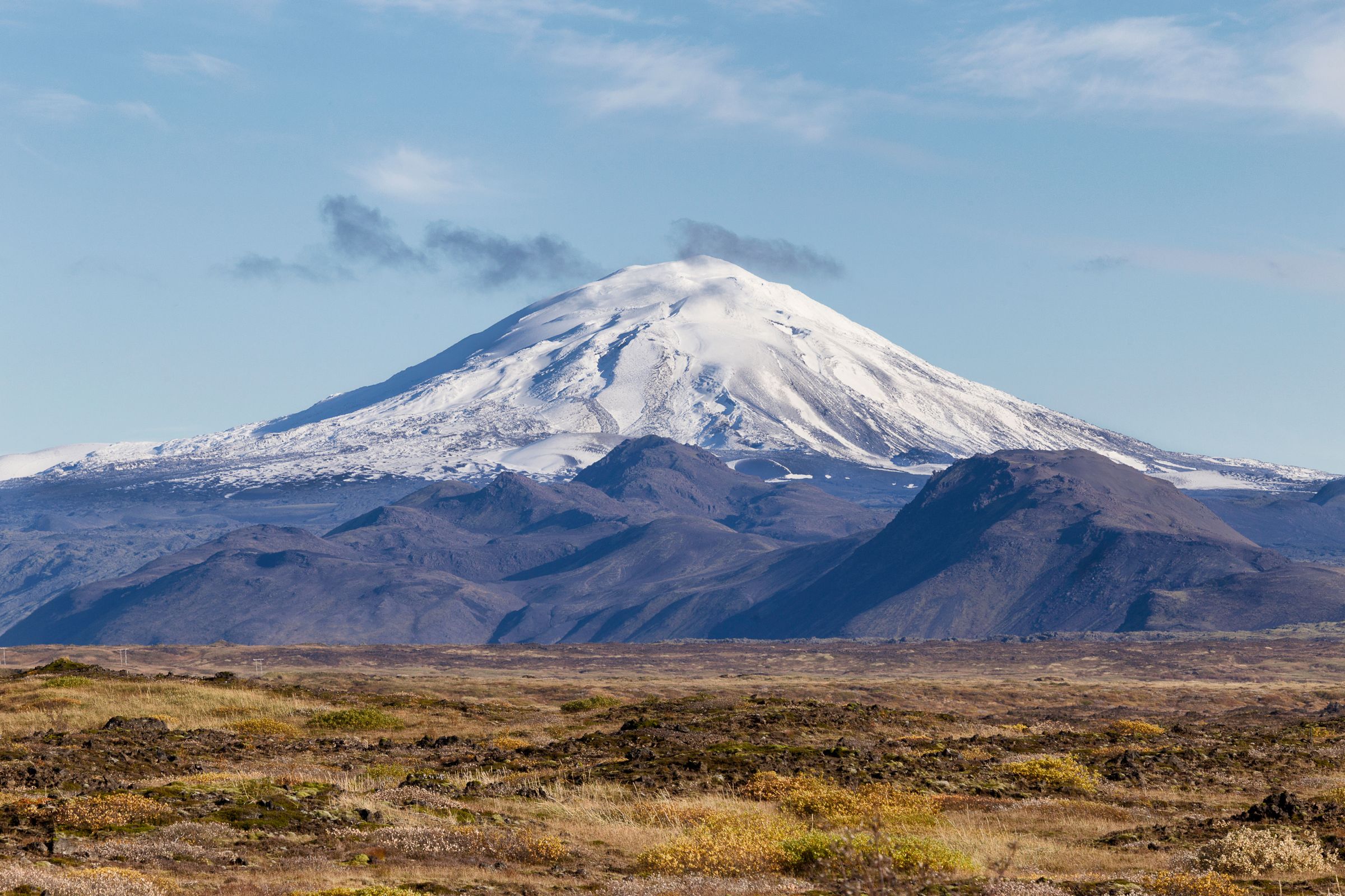
Hekla Volcano
One of Iceland's most active volcanoes, Hekla, has erupted over 20 times in recorded history. This is since the first settlers arrived on the island, in the 9th Century. The last one of them occurred in the year 2000. Although the top is covered in snow for most of the year, Medieval Icelanders used to call it the “Gateway to Hell,” due to its constant eruptions.
What to See and Do Near Fjallabak Nature Reserve
Fjallabak Nature Reserve, as we have seen, is a collection of different and amazing ecosystems that are waiting for you to discover them. It’s also in the middle of the highlands, an area that is as remote as impressive. And the surroundings have a bit of everything, especially south of the highlands.
Þórsmörk (Thorsmork)
Named after the Norse god Thor, this green valley seems out of a fantasy novel, contrasting with the black lava fields around. It’s also the ending point of the Laugavegur trail, the most famous hiking route in Iceland. There are several rivers crossing the valley, and also a couple of places to stay overnight with your campervan.

Seljalandsfoss
This tall waterfall is one of the most iconic and visited in the country. Located in the South Coast, just south of the reserve, it’s an impressive 60-meter (197 feet) drop that creates a rainbow mist when the sun is out. But what makes Seljalandsfoss stand apart is that it has a walking path that goes behind the curtain of water, allowing you to get a unique point of view. It’s very close to the Ring Road and the access is quite easy.

Gljúfrabúi
A few meters from Seljalandsfoss, we can find Gljúfrabúi, another waterfall. It’s not as big as its neighbor, but it sure is beautiful. It’s hidden inside a canyon, and it’s not visible from the outside. You need to wade through a shallow stream to get to it. At the end, a chamber opens up with the 40-meter (131 feet) cascade pouring down on rocks covered in green moss. It’s not as famous as Seljalandsfoss, so many tourists skip it, but is a marvelous surprise for the ones who take a few more minutes in this stop and see the two in one swing.

Where to Stay Near Fjallabak Nature Reserve
Camping in the highlands is possible, but you need to be self-sufficient. Wild camping is forbidden in all Iceland, but there are several campsites that offer spots for campervans, although they are mostly quite basic.
Landmannahellir
This remote campsite sits in a volcanic valley, offering tent pitches and campervan spots with access to hot springs. Facilities include toilets, a shower, and a BBQ area. Eight cottages can be rented. It's ideal for hikers, as several trails are starting nearby.
Álftavatn
Located along the Laugavegur trail, about halfway, this site features both hut accommodations and a camping area. Operated by Ferðafélag Íslands (The Iceland Touring Association, FÍ) there are two big huts with total capacity for 72 people. Amenities include shared bathrooms, cooking areas, and hot water.
Hvannagil Hut
Also along the Laugavegur trail and operated by FÍ, too. It consists of a big mountain hut with two large dormitories with bunk beds. There’s a smaller cabin outside with toilets and showers. You can also stay in the camping area, which also gives access to the common areas and services.
Strútur Hut
This place is another combination of a mountain hut and a camping area. It has toilets, showers, a shared kitchen (kitchenware included), and a grill area outside. It’s located in an astonishing volcanic area.
Sveinstindur
This hut is a refurbished shelter that was used by shepherds to find shelter when bad weather struck. It was rebuilt using the traditional Icelandic architectural style. You can sleep inside the hut or in the camping area by its side, both in a tent or campervan. It has toilets and a gas stove for cooking your own meals.
Langisjór Campsite
Rather than a camping ground, it’s an area where it’s allowed to park your campervan or set up your tent for the night. The facilities are really basic, just toilets and cold running water. There are no huts, electricity, or shops—just raw nature and tranquility.

Where's Fjallabak Nature Reserve and How to Get There
Travelling to Fjallabak Nature Reserve is not precisely easy. As we have already mentioned a few times, this protected area is in the southern part of the Icelandic Highlands, an isolated and remote region. Getting there is tricky, but the landscapes one enjoys along the way are part of the adventure. You’ll see different places unfold in front of you, each one more impressive than the previous one.
The best way to go there is by having your own vehicle. There is no public transport going to the reserve. Some companies offer tours or excursions to the Highlands, but you’ll have to follow a tight schedule, and it can be pretty pricey. If you rent a campervan, you’ll have the freedom to go to different parts of the reserve, at your own pace, and have a place to sleep and continue discovering the region the following day.
We’re going to describe the route to Landmannalaugar, which is the most accessible and common gateway to the reserve:
If you’re coming from Reykjavik, which is a common starting point for many trips inside Iceland, start by taking the Ring Road (Route 1) eastbound. After 87 kilometers, turn north onto Route 26 and drive on it for another 50 kilometers. Take the F225 until you reach the crossroads with F208. Five kilometers on this road and you’ll reach Landmannalaugar. These last two roads, as well as any you see starting with the letter F, are F-roads, so drive cautiously on them. Also, it is mandatory to have a 4x4 vehicle to drive on them, a conventional campervan can’t handle this type of road.
The total distance from the capital is around 180 kilometers (112 miles), and it takes about 3 hours to complete. It’s only possible to make this route during the summer months, as the weather makes the F-roads impassable the rest of the year. Even in summer, always check the road status to avoid unpleasant surprises.

The Weather at Fjallabak Nature Reserve
As the weather is quite extreme for most of the year, Fjallabak Nature Reserve is open only in summer, typically from June to mid-September. During this time, the F-roads are clear of snow, and most of the roads in the country are open to traffic. The average temperature year-round in Fjallabak is 0-1°C (32-34°F). The winters are long, lasting from November to March, with an average temperature of -6°C (21°F), and heavy snow often closes access.
In summer, the weather is mild, with the temperature oscillating between 5-15°C (41-59°F). However, the climate in Iceland is quite unpredictable and is constantly changing, so it’s essential to be prepared for all events. It can change from sun to rain, wind, or fog in a matter of minutes. If the wind comes from the south, expect rain almost certainly. If it comes from the north, it probably means drier weather, but lower temperatures.

What to Pack to Visit Fjallabak Nature Reserve
- Sturdy hiking boots with good grip and ankle support to deal with the uneven terrain.
- Waterproof jacket and pants to handle sudden rain.
- Layered clothing. The weather changes so fast that the best way to adapt to these changes is to wear layers. A thermal base layer, a moisture-wicking one as intermediate, and a waterproof outer layer.
- Warm hat, gloves, and scarf for cool evenings, even in summer.
- Reusable water bottle and food. There are no shops in the highlands.
- Detailed map or GPS device for navigation. There are areas with no cell phone service, so don’t rely on online maps exclusively.
- Sunscreen and sunglasses. The sun can be surprisingly strong up there.
- First-aid kit with basics like bandages and insect repellent.
- Portable charger. Most of the campsites don’t have electricity.

Travel Tips
- Plan your visit for the summer. It’s almost impossible to visit Fjallabak Nature Reserve outside of the summer months.
- Fill up on fuel and groceries in Selfoss or Hvolsvöllur before entering the highlands. There are no shops or gas stations.
- Respect the environment. Don’t wander off marked trails and take all your trash with you.
- Some F-roads include river crossings. Check the depth and current and don’t cross unless you’re sure there’s no danger in doing so.
- If you want to stay in huts, book in advance; some can fill up quickly.
- Check weather updates daily. The Icelandic Met Office provides the most accurate forecasts.
- If hiking alone, inform someone of your itinerary.
Conclusion
Iceland has become an increasingly popular travel destination. The main reason is that, here, nature is on full display. The number of different and astonishing environments that can be visited here is unparalleled. Some regions have some of the best sights to see in the country. One of them is Fjallabak Nature Reserve. Here, the landscapes are painted in gorgeous colors, and one can see waterfalls, volcanic deserts, colorful mountains, geothermal areas, and much more. Rent a 4x4 campervan, plan your route, and get ready for an authentic Icelandic adventure.


