

Finding Iceland on the Map: Location, Geography and Key Information
Iceland sits in the North Atlantic Ocean between Europe and North America. This land of fire and ice, where glaciers coexist with active volcanoes, draws travelers with its unique landscapes.
But exactly where is this island nation, and why does its location matter? Whether you're planning a trip to see the Northern Lights or just curious about this country, understanding Iceland's position helps explain its scenery, culture, and how to get there.
Let's examine Iceland's position on the map, how its location impacts everything from the weather to daily life, and what you need to know before visiting.
Key facts about Iceland’s location
- Region: North Atlantic / Northern Europe
- Relative location: between Greenland and Norway
- Nearest major reference: northwest of the UK
- Latitude: 63°N–66°NArctic Circle: Grímsey crosses it
- Tectonic position: Mid-Atlantic Ridge
- Capital: Reykjavík
Where Exactly Is Iceland?
Iceland is an island in the North Atlantic Ocean, sitting just below the Arctic Circle. On a map, you'll find it between Greenland and Norway, with the United Kingdom to the southeast.
The country spans from 63°N to 66°N latitude, making it one of the world's northernmost countries. While most of Iceland sits just south of the Arctic Circle, the small island of Grímsey crosses this boundary, giving Iceland a small piece of Arctic territory.
Iceland is closer to its neighbors than many people realize:
- Greenland is about 280 km (174 miles) to the northwest
- The Faroe Islands lie roughly 400 km (248 miles) to the southeast
- The UK is approximately 800 km (497 miles) away
- Norway sits about 950 km (590 miles) to the east
Despite these short distances, Iceland feels quite isolated. With a total area of 103,000 square kilometers (39,769 square miles), it's about the size of Kentucky or slightly smaller than England and Wales combined.
Reykjavik, the capital city, sits on the southwestern coast and is the world's northernmost capital of a sovereign state. Nearly two-thirds of Iceland's small population of approximately 398,000 people reside in the greater Reykjavik area, leaving much of the country with a sparse population.
Is Iceland in Europe or North America?
Iceland is generally considered part of Europe, both politically and culturally. It is a Nordic country with close historical, economic, and political ties to other European nations such as Norway, Denmark, and Sweden, and it participates in European institutions like the European Economic Area (EEA) and the Schengen Area.
However, Iceland’s geology is unique. The island sits directly on the Mid-Atlantic Ridge, the boundary between the North American and Eurasian tectonic plates. This means that, from a geological perspective, Iceland actually lies on both plates at the same time. In places like Þingvellir National Park, visitors can even see the rift valley where the two plates are slowly pulling apart.
In simple terms, Iceland is considered part of Europe geographically and politically, but geologically it straddles the boundary between North America and Eurasia in the North Atlantic Ocean.
Neighboring Countries and Strategic Position
Iceland's location has given it strategic importance throughout history, particularly during World War II and the Cold War, when its position made it valuable for monitoring shipping and aircraft movements in the North Atlantic.
Today, Iceland maintains close relationships with its neighbors:
- Denmark ruled Iceland until 1944, and cultural ties remain
- The Nordic countries (Sweden, Norway, Denmark, Finland) share cultural connections
- The UK and the US are major trading partners
Iceland's membership in NATO and the European Economic Area, but not the European Union, reflects its position between continents. The country maintains its own currency (the Icelandic króna) and manages its valuable fishing waters independently.
The Mid-Atlantic Ridge: Why Iceland Is Literally Split in Two
One of Iceland's most interesting geographical features isn't visible at first glance. The country sits directly on the Mid-Atlantic Ridge, where the North American and Eurasian tectonic plates are slowly pulling apart.
This position explains why Iceland exists. As these massive plates drift away from each other at about 2 cm per year, magma rises from below, creating new land. This ongoing process makes Iceland one of the youngest landmasses on Earth, formed only about 18 million years ago.
You can see this continental divide at Thingvellir National Park, where a rift valley shows the separation between the plates. It's one of the few places on Earth where you can walk between two continents and see geology in action.
This geological setting gives Iceland its most distinctive features:
- Active volcanoes (about 30 systems with over 100 volcanic centers)
- Frequent earthquakes (usually small, with hundreds occurring daily)
- Abundant hot springs and geysers
- Vast lava fields cover about 11% of the country
Iceland's location on the Mid-Atlantic Ridge makes geothermal energy an abundant resource. This renewable resource heats nearly every building in the country and provides hot water for the many swimming pools and hot springs. The Blue Lagoon, located near Keflavik Airport, is just one example of how Icelanders have harnessed this natural resource.
The island's volcanic soil isn't ideal for traditional farming, but Icelanders have adapted by focusing on greenhouse agriculture (heated geothermally) and raising sheep and horses that are suited to the rugged landscape


Climate Contradictions: Why Iceland Isn't As Cold As You'd Think
Given its name and northern location, you might expect Iceland to be frozen year-round. Surprisingly, its climate is milder than many places at similar latitudes, thanks to the Gulf Stream that brings warm water from the Gulf of Mexico across the Atlantic.
This ocean current moderates temperatures, especially in winter. Reykjavik's average January temperature hovers around 0°C (32°F), while summer temperatures typically range from 10-15°C (50-59°F). This creates a subarctic climate that's chilly but not extremely cold.
Iceland's position near the Arctic Circle also creates big seasonal variations in daylight:
- Summer brings the Midnight Sun, with nearly 24 hours of daylight in June
- Winter days have only 4-5 hours of dim daylight in December
- Spring and fall have more balanced day/night cycles
The island's location also makes for changeable weather. Conditions can shift rapidly from sunshine to rain to snow, sometimes all in the same day.
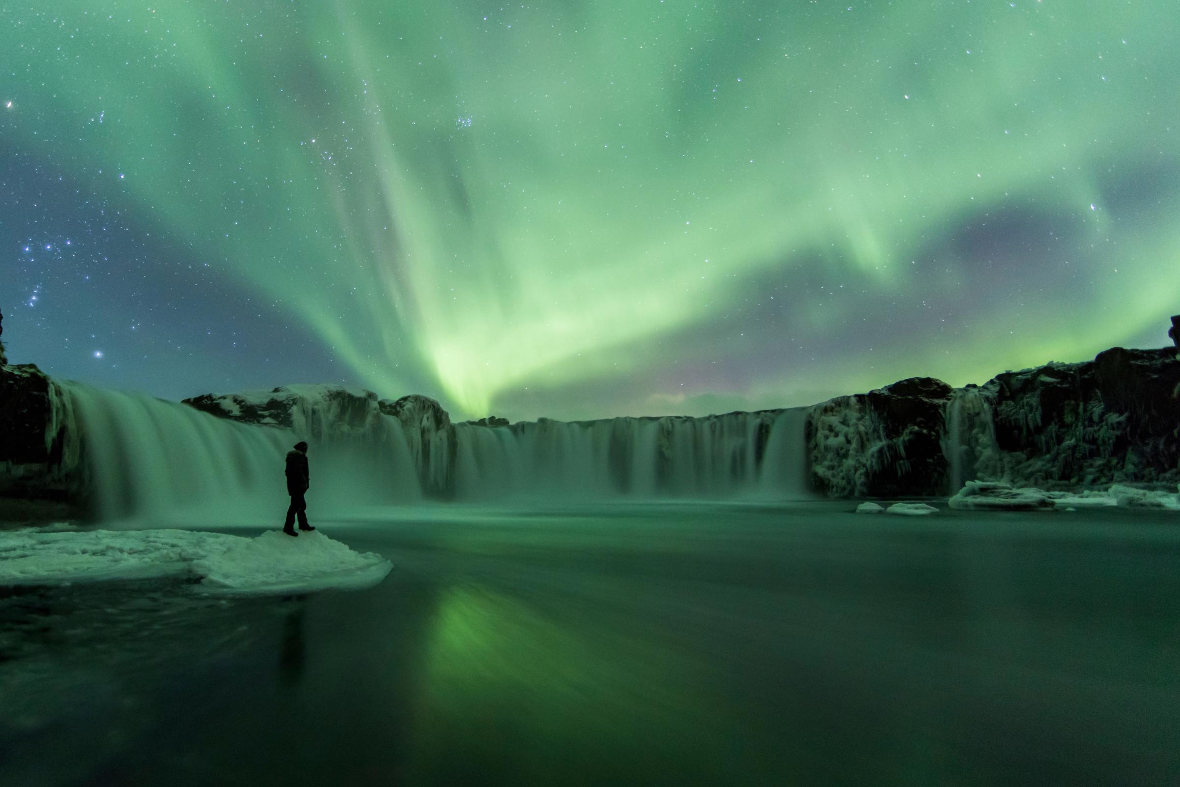
This position also makes Iceland one of the best places to see the Northern Lights (Aurora Borealis) during winter months, when dark skies provide the perfect backdrop for this natural phenomenon.
Cultural Isolation: How Location Shaped Icelandic Identity
Iceland's isolated position has influenced its culture and history. Settled primarily by Norse Vikings in the 9th century, with some Celtic influence, Iceland developed separately from mainland European trends.
This isolation helped preserve the Icelandic language, which remains similar to Old Norse. While other Nordic languages changed significantly, Icelanders can still read ancient Viking sagas in their original form with relatively little difficulty.
Iceland's fishing industry developed as a natural response to its position surrounded by the rich waters of the North Atlantic. These abundant fishing grounds have helped sustain the population through centuries of harsh conditions and remain important to the economy today, alongside newer industries such as tourism and renewable energy.

Getting to Iceland: Flight Times and Routes
Thanks to modern air travel, Iceland's isolation has become less of a barrier. Keflavik International Airport, located approximately 50 km from Reykjavik, serves as the country's main gateway.
Flight times from major cities:
- London to Keflavik: 3 hours
- New York to Keflavik: 5.5-6 hours
- Toronto to Keflavik: 5.5 hours
- Paris to Keflavik: 3.5 hours
Icelandair, the country's flagship carrier, has used Iceland's mid-Atlantic position by offering free stopovers of up to 7 days for passengers flying between North America and Europe. This strategy has significantly boosted tourism.

Iceland's Time Zone
Iceland operates on Greenwich Mean Time (GMT) year-round, making it the same time as London during winter. Unlike most European countries, Iceland doesn't observe daylight saving time, which creates some interesting time differences during summer:
- 2 hours behind most of Western Europe (CEST)
- 4 hours ahead of New York (EDT)
- 7 hours ahead of Los Angeles (PDT)
- 1 hour behind London during British Summer Time
This time zone choice makes practical sense given Iceland's longitude, but it creates some unique situations. During summer, you might find yourself having dinner at 10 PM while the sun is still high in the sky, or enjoying daylight at midnight.

Conclusion
Iceland's position at the junction of the North Atlantic and Arctic Ocean, straddling two continental plates, has created a land of extremes and contradictions. This small island nation offers experiences you can't find anywhere else, from walking between continents to swimming in naturally heated pools while surrounded by snow.
Frequently Asked Questions About Iceland


